Sunday, 13 December
Palm coast to Daytona Beach
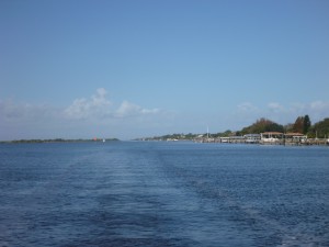
We left Palm Coast Marina in the morning with no issues. We expected a relatively uneventful day after we navigate two minor “hazard” areas as identified by ActiveCaptain. For the first time there are absolutely NO hazards of shoaling or anything else to cause us concern for the rest of the day.
We knew not to get too complacent, but were enjoying watching the scenery go by.
In an area that didn’t have any hazards listed and no visible signs of problems, we found ourselves stopped and aground. We did a quick survey of the charts and electronics to try to determine where the deeper water would be found and Bob was able to back us off the sandbar and into deeper water.
In review of the situation, there had been two green markers and Bob had steered to what he thought was the middle of the channel. The electronic chart shows the middle of the channel with a magenta line. In reviewing this chart it showed that the “middle” of the channel was actually close to those greens.
 Throughout this trip we haven’t really focused on the magenta line because in so many of the “hazard” comments along the way the continual theme is don’t follow the magenta line blindly, follow the visual channel. Many people get into trouble when they navigate purely with the electronic instruments without using the actual markers and visual sightings. There are known errors with the charts which is why it is important to use all the tools at your disposal….including your eyes. But with today’s grounding we guess we will be following the magenta line more closely through Florida, where the canal is wide but the channel is narrow.
 Approaching Daytona Beach at the end of the day entailed crossing under two draw bridges where we had to request openings, and two unrestricted fixed bridges in short order. This is the prettiest bridge we have crossed under to date.
We were thankful for our 55 foot mast because it was close to high tide and even though the two fixed bridges have 65 foot clearances, the height markers indicated only 62 or 62.5 feet clearance. We heard multiple boats on the radio trying to figure out when the water would drop lower so they could clear the bridge with their 63 foot (or higher) masts. In the meantime they were forced to anchor alongside the channel to wait for the tide to go down.
We were able to make it easily to our marina, dock with no issue and enjoy another quiet evening.